
Wood Hill/Bald Hill
|
Size: 203 acres
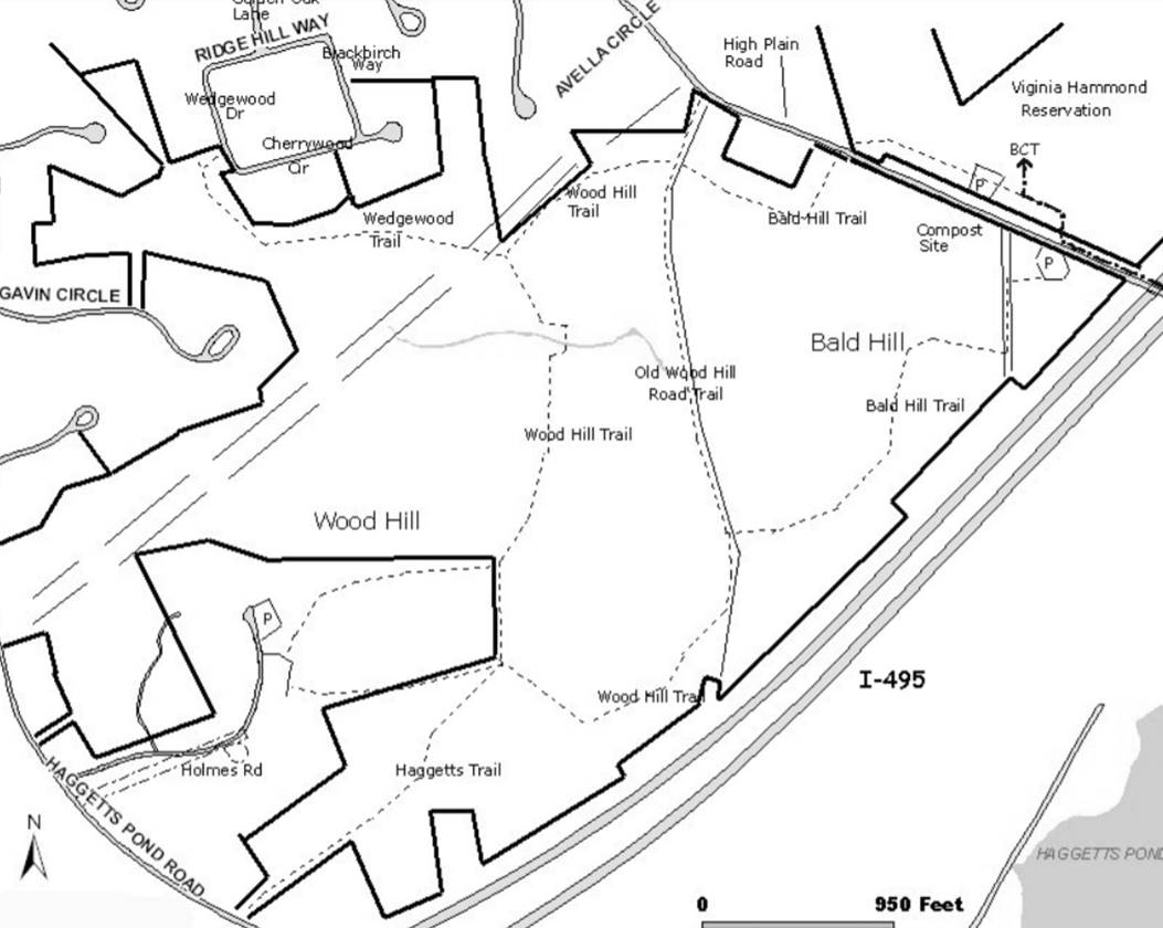
Location: Between High Plain Road, Hagget's Pond Road, and Route 495 Parking: Parking area 400 feet east of leaf composting areaWood Hill/Bald Hill Fantastic New Orienteering Course! Thanks to Eagle Scout Dan O'Leary, Andover has a great new set of 3 orienteering courses in the Bald Hill / Wood Hill Reservation. Orienteering is a sport for a lifetime, for people of all ages and abilities. Participants travel alone or in groups, running or walking, as a competition or simply to savor nature's beauty. Orienteering challenges you to read a map, make decisions, and plan a route all while moving across fields, over rocks and along scenic trails. The Bald Hill/ Wood Hill permanent orienteering courses offer three variations: one course for beginners, one advanced, and one expert. Click HERE to download the Course Guide Reservation Features: Wood hill and Bald Hill are glacial formations known as drumlins, smooth rounded hills composed of clay, sand, and gravel, pebbles, and boulders. They formed when the moving ice sheets pushed together and molded masses of sticky glacial till. They are characterized by an oval, lens shaped outline, oriented in the direction of glacial movement. Bald Hill is not really bald; small white pines, birches and juniper cover the summit. Healthy sumac bushes and interesting small evergreens grow on the grassy eastern side. Farther down Bald Hill and on Wood Hill, tall pines and oaks flourish. Look for American chestnut saplings growing from rootstock of pre-1930s blight chestnut trees. The northern descent from Wood Hill passes through large areas of ferns and blueberry bushes. History: Although Wood Hill Road is now little more than a trail in some places, the stone walls on either side, the occasional ruins of a building and some very large trees that once shaded the front yards of the houses nearby are evidence of its former importance. Back from the road, a few stone walls suggest that the area may once have used as pasture land. It is also likely, however, that these forests provided woodlots for farmers along the Merrimack River and people in town, thus producing the name Bald Hill. The prime blueberry picking area at its summit was helped by the occasional fires in the 1930�s that kept the tree growth down, ensuring a steady supply of sturdy young blueberry bushes. 370 foot high Wood Hill was the site of an airplane beacon that had to be turned off during World War II blackouts. The hilltop is now home to radio and cellular phone towers and two of Andover�s reservoirs. Suggested Walks: From the parking area 400� east of the Town composting area a trail leads to the old cart path leading southeast to the Bald Hill Trail on the right. The trail ascends south over the top of Bald Hill then descends to Old Wood Hill Road. A right turn will take you back to High Plain Rd. or the return loop of the Bald Hill Trail. For a longer walk, turn left and follow the Wood Hill Trail to the top of Wood Hill. Unfortunately tree growth has obscured the views from the top. Three quarters of the way to the top you will find Haggetts Trail leading westerly to Haggetts Pond Rd. At that point you may turn right following a trail by-passing private land bringing you back to Wood Hill Trail. Following Wood Hill Trail northward through the �Glen� where benches have been provided, then to the top of the slope where the Wedgewood Trail turns left taking you to Wedgewood Rd in the Golden Oaks development. Continuing on the Wood Hill Trail easterly you will come to Old Wood Hill Rd. again. Crossing Old Wood Hill Rd to the continuation of the Bald Hill Trail northeast, crossing High Plain Rd and entering the Virginia Hammond conservation area and follow the trail east to the parking area across High Plain Road. |
|