• Our Trails
    • Andover Trails Guide, 6th edition
  • Shawsheen River
    • History
    • Paddle Your Shawsheen
    • Where to Paddle >
      • Dale St - Central St (Abbot Bridge Dr)
      • Shawsheen Pines - Serio's Grove - Ballardvale
    • Safety & Areas to Avoid
    • Water Levels
  • Activities
    • Paddling
    • Hiking
    • Biking >
      • Bicycle Routes
    • Fishing and Hunting
    • Orienteering
  • Events
    • Lecture Series - Does the Appalachian Trail Call to You?
    • Youth and Family Treasure Hunt
  • Blog
  • About
    • Board
    • Donate
    • Volunteer
    • Affiliates
    • Contact
ANDOVER TRAILS LIVE
  • Our Trails
    • Andover Trails Guide, 6th edition
  • Shawsheen River
    • History
    • Paddle Your Shawsheen
    • Where to Paddle >
      • Dale St - Central St (Abbot Bridge Dr)
      • Shawsheen Pines - Serio's Grove - Ballardvale
    • Safety & Areas to Avoid
    • Water Levels
  • Activities
    • Paddling
    • Hiking
    • Biking >
      • Bicycle Routes
    • Fishing and Hunting
    • Orienteering
  • Events
    • Lecture Series - Does the Appalachian Trail Call to You?
    • Youth and Family Treasure Hunt
  • Blog
  • About
    • Board
    • Donate
    • Volunteer
    • Affiliates
    • Contact
Doyle Link

NOTE: Many interior trails have been closed by Andover Conservation to allow forest regeneration. A new trail map is under construction and the existing (red-blazed) loop trail will be remarked by Spring 2026. In the meantime, please obey all posted signage. 

Features:

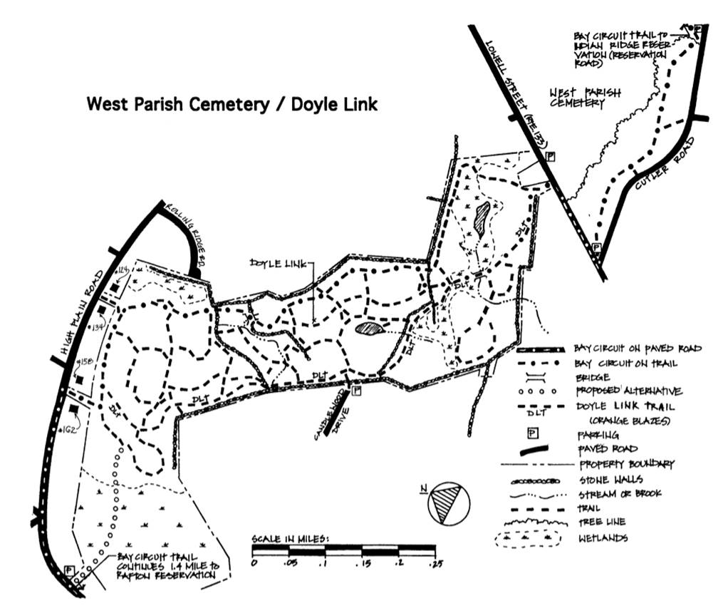
Doyle Link is part of the Andover drinking water supply watershed. It encompasses two ponds, several streams and a red maple swamp on the Greenwood Road end. Beautiful colors in fall. Several stands of white pines grow among the hardwood trees. Interesting rock outcroppings can be found in the western section of Doyle Link.

History:
Before the decision of Andover Town Meeting in 1974 to purchase the Doyle Link, it was used as woodlot and pasture land. Plans to use it for a town recreation area never materialized.

Permitted Uses:
Hiking, ski touring, horses, and bicycles are all allowed in Doyle Link so trail courtesy and sharing must be practiced at all times. For safety reasons, bicycles are not permitted on the raised boardwalk to High Plain Road. Bay Circuit through riders should use instead the shorter marked trail between house numbers 158 and 162. 

Size: 75 acres
Location: Lowell Street (Route 133) opposite West Parish Cemetery, High Plain Road, Candlewood Lane
Parking: Near cemetery gates; Juniper Road off High Plain Road
​
Picture

OUR TRAILS

SHAWSHEEN

ACTIVITIES

EVENTS

ABOUT

Copyright © 2025
  • Our Trails
    • Andover Trails Guide, 6th edition
  • Shawsheen River
    • History
    • Paddle Your Shawsheen
    • Where to Paddle >
      • Dale St - Central St (Abbot Bridge Dr)
      • Shawsheen Pines - Serio's Grove - Ballardvale
    • Safety & Areas to Avoid
    • Water Levels
  • Activities
    • Paddling
    • Hiking
    • Biking >
      • Bicycle Routes
    • Fishing and Hunting
    • Orienteering
  • Events
    • Lecture Series - Does the Appalachian Trail Call to You?
    • Youth and Family Treasure Hunt
  • Blog
  • About
    • Board
    • Donate
    • Volunteer
    • Affiliates
    • Contact