• Our Trails
    • Andover Trails Guide, 6th edition
  • Shawsheen River
    • History
    • Paddle Your Shawsheen
    • Where to Paddle >
      • Dale St - Central St (Abbot Bridge Dr)
      • Shawsheen Pines - Serio's Grove - Ballardvale
    • Safety & Areas to Avoid
    • Water Levels
  • Activities
    • Paddling
    • Hiking
    • Biking >
      • Bicycle Routes
    • Fishing and Hunting
    • Orienteering
  • Events
    • Lecture Series - Does the Appalachian Trail Call to You?
    • Youth and Family Treasure Hunt
  • Blog
  • About
    • Board
    • Donate
    • Volunteer
    • Affiliates
    • Contact
ANDOVER TRAILS LIVE
  • Our Trails
    • Andover Trails Guide, 6th edition
  • Shawsheen River
    • History
    • Paddle Your Shawsheen
    • Where to Paddle >
      • Dale St - Central St (Abbot Bridge Dr)
      • Shawsheen Pines - Serio's Grove - Ballardvale
    • Safety & Areas to Avoid
    • Water Levels
  • Activities
    • Paddling
    • Hiking
    • Biking >
      • Bicycle Routes
    • Fishing and Hunting
    • Orienteering
  • Events
    • Lecture Series - Does the Appalachian Trail Call to You?
    • Youth and Family Treasure Hunt
  • Blog
  • About
    • Board
    • Donate
    • Volunteer
    • Affiliates
    • Contact

Where to Paddle

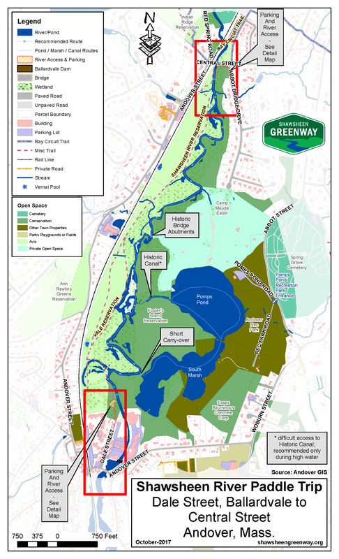
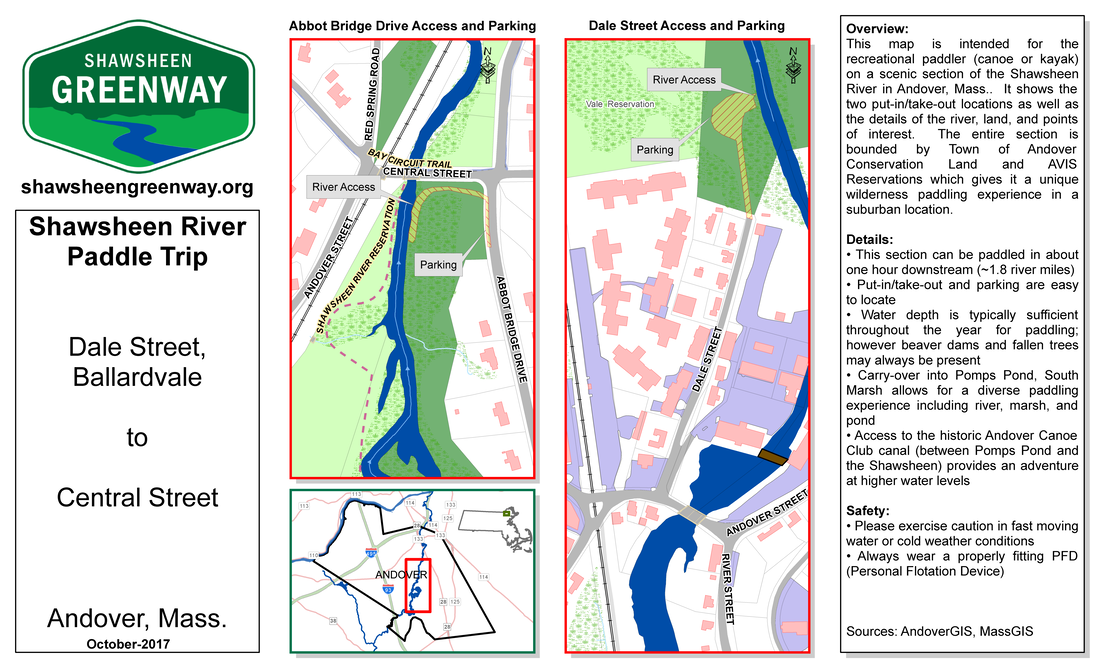
Dale Street - Central Street (Abbot Bridge Drive)

This section runs from immediately below the Ballardvale dam at Dale Street downstream to Central Street at the Abbot Bridge Drive canoe launch. 
  • The most recommended section for family friendly paddling at both low and high-water levels. 
  • 1.8 river miles (about one hour downstream) through the woodlands and marsh of protected lands of AVIS and Andover Conservation for a wilderness-like experience. 
  • Good parking and access at the end of Dale Street (dirt parking lot) and along Abbot Bridge Drive (short walk from the street to the launch). 
  • Scouted and maintained by Shawsheen Greenway. 
  • Can be paddled in most water levels upstream (some effort) or downstream for flexibility of put-in location and paddling effort. 
  • For more exploring, you can carry over the berm into the South Marsh of Pomps Pond (a short way downstream from Dale St.) and see a diversity of wildlife. The marsh can be paddled only in high water, generally early season. 
  • Another exploration is to travel the old ‘Andover Canoe Club’ hand-dug canal from the half-way point on the trip over to Pomps Pond. This is only accessible at higher water levels and may require local river knowledge to locate. 
Warning: It is not recommended to paddle downstream from Central Street! This section has fast water sections and a breached dam with a very narrow, rocky, fast channel that is not appropriate for family friendly paddling. Also, there are no good access points downstream of Central Street. 

Map (PDF):
This map is available to assist in paddling this area.
A color, glossy, foldable printed copy is available for purchase – Contact Us. ​
Print on 11" x 17" stock.
Picture
Picture

OUR TRAILS

SHAWSHEEN

ACTIVITIES

EVENTS

ABOUT

Copyright © 2025
  • Our Trails
    • Andover Trails Guide, 6th edition
  • Shawsheen River
    • History
    • Paddle Your Shawsheen
    • Where to Paddle >
      • Dale St - Central St (Abbot Bridge Dr)
      • Shawsheen Pines - Serio's Grove - Ballardvale
    • Safety & Areas to Avoid
    • Water Levels
  • Activities
    • Paddling
    • Hiking
    • Biking >
      • Bicycle Routes
    • Fishing and Hunting
    • Orienteering
  • Events
    • Lecture Series - Does the Appalachian Trail Call to You?
    • Youth and Family Treasure Hunt
  • Blog
  • About
    • Board
    • Donate
    • Volunteer
    • Affiliates
    • Contact