Pomp's Pond/Foster's Island
|
Features:
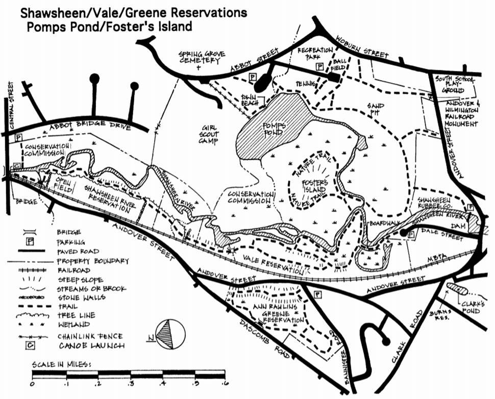
The Shawsheen River rises gently from a Bedford meadow, eventually fl owing into the Merrimack River. Its name comes from the Indian words for “Great Spring” and “Beauty’s Pathway.” Meandering northward through the middle of Andover, the Shawsheen River offers canoeists and walkers a chance to observe wildlife and water plants at close range. The river is shallow between Ballardvale dam and Abbot Bridge, but still canoeable in all except the driest times. Extensive cattail marshes make walking difficult along the east side of the river. Public access to Foster's Island requires waterproof boots in most seasons. Take the Community Path through the Shawsheen Rubber parking lot, 220 Andover Street, pass AK Thomas and enter the woods. At an old sign, the trail branches; the right-hand trail goes to the Gravel Pit and Recreation Park, the left-hand unmarked trail goes to Foster's Island. Take the left-hand trail, noting the ample signs of recent beaver activity. At the point where the trail is flooded, the low beaver dam on the left is traversable and brings you to solid ground in 15-20 yards. Once back on dry ground continue straight past the boulder on the right (where the original trail, now flooded, turns to the right) to the river where you will find a narrow path to your right that goes along the top of the berm on the river's edge. This path brings you to the berm leading to Foster's Island where you find clearly marked trails. Once on Foster's Island, to your immediate right is a steep climb to the high point of the island that gives a nice view of the marshes; the climb is more gradual from the other side. History: A few hundred years ago, much of this land belonged to the Ballard family and Pomp's Pond was known as Ballard Pond. The Ballards and others used the power of the Shawsheen to run sawmills and textile mills. This area became known as Ballardvale and it remained a thriving industrial center through the end of the 19th century. The current name of Pomp's Pond refers to Pompey Lovejoy, a freed slave who built a cabin near the pond on Abbot Road, fished, and farmed nearby land. Pompey Lovejoy died in the 1820s, over a hundred years old. The land between Pomp's Pond and Central Street was the Foster poultry farm; the farmhouse can be seen from Central Street and Abbot Bridge Road. A 1915 map shows the Andover Canoe Clubhouse near the Abbot Bridge. In addition to renting canoes, people could also take a trip on the motor yacht “Wm. Ballard.” The river was considerably higher then, and the Canoe Club had built a half mile long canal linking the river to Pomp's Pond. With only a ten-inch draft, the motor launch could carry 30 passengers to the pond for picnic suppers. Several generations ago, Andover residents enjoyed swimming in the Shawsheen. The river and the swimming adventures of Phillips Academy boys were immortalized in “The Schoolboy,” a poem by Oliver Wendell Holmes. In the 1940s, Camp Maude Eaton, a Girl Scout camp, was established on the north shore of the pond. The Girl Scout camp is private property and not open to hikers. The Conservation Commission purchased the Recreation Park area and Foster's Island in 1967. Size: 101 acres Parking: Recreation Park; Abbot Bridge Drive; near Ballardvale dam; small lot on Red Spring Road Access: Recreation Park off Abbot St.; trail beyond Shawsheen Rubber Co. in Ballardvale; trails from Woburn and Andover Sts.; canoe launch sites at end of Dale St. and at Central St. Bridge. |


