Bicycle Routes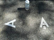
The Andover bike loops are marked with large stenciled white "A" along the route inside the curb. The markings are located before and after each turn. In addition to the full 24 mile loop there is a shorter 9 mile loop - the "Shortcut" - marked with the same "A" stencil with a small "s" at the bottom. The "Shortcut" is designed for beginners and those seeking gentler slopes and less traffic.
TO USE THE ROUTES - click on the link below for the route you wish to do. You can send this to your device for riding. And there are cue sheets. The route markings are refreshed each year late in the spring. Enjoy! 9-Mile East-Side Beginners Loop: “The Shortcut"
This route is intended to be ridden in a clockwise direction to minimize left turns. The road is marked with an “A” pointing in the intended direction of all turns, with occasional confidence markers in between. There is an “s” at the base of the “A” only where the “Shortcut” departs from the primary route. This route starts at the Phillips Academy Bell Tower on Salem Street near the intersection with Main Street (Rt. 28). https://ridewithgps.com/routes/26738386 (9.1 mi, 445’ elev) 24-Mile Andover Bike Loop: “The Andover Challenge"
This route is intended to be ridden in a clockwise direction to minimize left turns. The road is marked with an “A” pointing in the intended direction of all turns, with occasional confidence markers in between. This route starts at the Andover Town Offices parking lot on Bartlet Street. Andover 24-mile bike loop · Ride with GPS (23.6 mi, 1226’ elev) |

|
-
Our Town Trails
- Andover Trails Guide, 6th edition
- Bay Circuit Trail
- Shawsheen River Greenway
- Bicycle Routes
-
Andover Conservation Commission Land
>
- Abbot Bridge Drive
- Bellevue Reservation
- Carmel Woods
- Castle Park
- Dale Street
- Doyle Link
- Jenkins Quarry Reservation
- Lightning Tree Reservation
- Mary French Reservation
- Haggett's Pond & Rail Trail
- Virginia Hammond Res.
- Merrimack River Reservation
- Penguin Park
- Pole Hill
- Pomp's Pond/Foster's Island
- Robert Pustell Reservation
- Serio's Grove Reservation
- Shawsheen Pines
- West Elementary School Woods
- Wood Hill/Bald Hill
- AVIS Reservations
- Massachusetts DCR
- Town of Andover Land >
- Trustees of the Reservations
- Other Land >
- Shawsheen River
- Activities
- Event Calendar
- Volunteer
- Donate
- About

-
Our Town Trails
- Andover Trails Guide, 6th edition
- Bay Circuit Trail
- Shawsheen River Greenway
- Bicycle Routes
-
Andover Conservation Commission Land
>
- Abbot Bridge Drive
- Bellevue Reservation
- Carmel Woods
- Castle Park
- Dale Street
- Doyle Link
- Jenkins Quarry Reservation
- Lightning Tree Reservation
- Mary French Reservation
- Haggett's Pond & Rail Trail
- Virginia Hammond Res.
- Merrimack River Reservation
- Penguin Park
- Pole Hill
- Pomp's Pond/Foster's Island
- Robert Pustell Reservation
- Serio's Grove Reservation
- Shawsheen Pines
- West Elementary School Woods
- Wood Hill/Bald Hill
- AVIS Reservations
- Massachusetts DCR
- Town of Andover Land >
- Trustees of the Reservations
- Other Land >
- Shawsheen River
- Activities
- Event Calendar
- Volunteer
- Donate
- About