• Our Trails
    • Andover Trails Guide, 6th edition
    • Bay Circuit Trail
    • Shawsheen River Greenway
    • Bicycle Routes
    • Andover Conservation Commission Land >
      • Abbot Bridge Drive
      • Bellevue Reservation
      • Carmel Woods
      • Castle Park
      • Dale Street
      • Doyle Link
      • Lightning Tree Reservation
      • Mary French Reservation
      • Haggett's Pond & Rail Trail
      • Virginia Hammond Res.
      • Merrimack River Reservation
      • Penguin Park
      • Pole Hill
      • Pomp's Pond/Foster's Island
      • Robert Pustell Reservation
      • Serio's Grove Reservation
      • Shawsheen Pines
      • West Elementary School Woods
      • Wood Hill/Bald Hill
    • AVIS Reservations
    • Massachusetts DCR
    • Town of Andover Land >
      • Fish Brook
      • Penguin Park
      • Sanborn School Woods
      • South School Woods
      • West Elementary School Woods
    • Trustees of the Reservations
    • Other Land >
      • Cochran Wildlife Sanctuary
      • Den Rock Park
      • West Parish Cemetery
  • Shawsheen River
    • Paddle Your Shawsheen
    • Where to Paddle >
      • Dale St - Central St (Abbot Bridge Dr)
      • Shawsheen Pines - Serio's Grove - Ballardvale
      • Shawsheen Pines - Sanborn Reservation (Tewksbury)
    • Safety & Areas to Avoid
    • Water Levels
    • History
  • Activities
    • Events Calendar
    • Hiking
    • Paddling
    • Fishing and Hunting
    • Biking
    • Events >
      • Past Events
  • Projects
    • Dam Removal Projects
    • RHC
    • River Crew
    • Bellevue Project
    • Bay Circuit Trail Bridge Project
    • Skug River Beaver Re-routes
  • Volunteer
  • Donate
  • News
  • Andover to Everest
  ANDOVER TRAILS LIVE
  • Our Trails
    • Andover Trails Guide, 6th edition
    • Bay Circuit Trail
    • Shawsheen River Greenway
    • Bicycle Routes
    • Andover Conservation Commission Land >
      • Abbot Bridge Drive
      • Bellevue Reservation
      • Carmel Woods
      • Castle Park
      • Dale Street
      • Doyle Link
      • Lightning Tree Reservation
      • Mary French Reservation
      • Haggett's Pond & Rail Trail
      • Virginia Hammond Res.
      • Merrimack River Reservation
      • Penguin Park
      • Pole Hill
      • Pomp's Pond/Foster's Island
      • Robert Pustell Reservation
      • Serio's Grove Reservation
      • Shawsheen Pines
      • West Elementary School Woods
      • Wood Hill/Bald Hill
    • AVIS Reservations
    • Massachusetts DCR
    • Town of Andover Land >
      • Fish Brook
      • Penguin Park
      • Sanborn School Woods
      • South School Woods
      • West Elementary School Woods
    • Trustees of the Reservations
    • Other Land >
      • Cochran Wildlife Sanctuary
      • Den Rock Park
      • West Parish Cemetery
  • Shawsheen River
    • Paddle Your Shawsheen
    • Where to Paddle >
      • Dale St - Central St (Abbot Bridge Dr)
      • Shawsheen Pines - Serio's Grove - Ballardvale
      • Shawsheen Pines - Sanborn Reservation (Tewksbury)
    • Safety & Areas to Avoid
    • Water Levels
    • History
  • Activities
    • Events Calendar
    • Hiking
    • Paddling
    • Fishing and Hunting
    • Biking
    • Events >
      • Past Events
  • Projects
    • Dam Removal Projects
    • RHC
    • River Crew
    • Bellevue Project
    • Bay Circuit Trail Bridge Project
    • Skug River Beaver Re-routes
  • Volunteer
  • Donate
  • News
  • Andover to Everest

Bay Circuit Trail

Picture


​Bay Circuit Trail
​
Interactive Map
​

​
Bay Circuit Trail
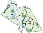
The Bay Circuit Trail is a permanent recreation trail and greenway extending through 37 towns in Eastern Massachusetts, linking parks and open space from the north shore to the south shore of Massachusetts.  The Bay Circuit Trail route in North Andover and Andover covers 19.1 miles. Its sections are described in the Guidebook and include (from East to West):
  • Harold Parker State Forest: Rte. 114 to Salem St. (2.5 miles); Salem St. to Jenkins Rd. (1 mile)
  • Skug & Hammond Reservations: Jenkins Rd. to Salem St. (1 mile); Salem St. to Korinthian Way (0.5 mile); Korinthian Way & Gray Rd. (0.2 mile)
  • Ward Reservation: Gray Rd. to Tucker Rd. (0.4 mile); Tucker Rd. to Prospect Rd. (1.6 miles); Prospect Rd. and Rte. 125 (0.3 mile)
  • Phillips Academy & Purdon Reservation: Rte. 125 to Central St. (1.8 miles); Central St. to Lupine Rd. (0.2 mile); Lupine Rd., Central St., Reservation Rd.(0.4 mile)
  • Indian Ridge & West Parish Meadow: Reservation Rd. to intersection of Cutler Rd. (1.3 miles)
  • West Parish Cemetery & Doyle Link: Reservation & Cutler Rds. to Rte. 133 (Lowell St.) (0.5 mile); Rte. 133 (Lowell St.) to High Plain Rd. (1 mile); High Plain Rd. (1.4 miles)
  • Rafton Reservation & Fish Brook: High Plain Rd. to jct. Chandler Rd. & River Rd. (2 miles); Launching Rd (0.3 mile)
  • Deer Jump Reservation: Launching Rd. to Tewksbury town line (2.7 miles)

The route of the Bay Circuit Trail is marked in Andover with round plastic markers bearing the Bay Circuit logo. 

Please note that bicycles are not permitted on AVIS trails.

ADVISORY APRIL 2022:  ​​Due to beaver activity, water levels in the Hammond (AVIS) and Mary French (Andover Conservation) reservations continue to top existing boardwalks and bog bridges by 3-4 inches. Footing remains safe but potentially unpleasant.
BCT through-hikers (westbound) who wish to keep their feet dry should proceed from the Skug Reservation left/northwest on Salem Street for 7/10 of a mile, enter the Ward Reservation on the right near the intersection with Gray Road, and rejoin the Bay Circuit Trail at the top of the hill.
Eastbound hikers may pass through the Ward and Great Swamp reservations to Gray Road and the intersection with Korinthian Way. The dry route is along Gray Road, 5/10 of a mile, to the intersection with Salem Street. Left on Salem Street for 7/10 of a mile and right into the Skug Reservation.  
Thanks for your patience. AVIS and Andover Conservation are working to remedy the situation!!!

EVENTS

VOLUNTEER

PROJECTS

DONATE

CONTACT

Copyright © 2018
  • Our Trails
    • Andover Trails Guide, 6th edition
    • Bay Circuit Trail
    • Shawsheen River Greenway
    • Bicycle Routes
    • Andover Conservation Commission Land >
      • Abbot Bridge Drive
      • Bellevue Reservation
      • Carmel Woods
      • Castle Park
      • Dale Street
      • Doyle Link
      • Lightning Tree Reservation
      • Mary French Reservation
      • Haggett's Pond & Rail Trail
      • Virginia Hammond Res.
      • Merrimack River Reservation
      • Penguin Park
      • Pole Hill
      • Pomp's Pond/Foster's Island
      • Robert Pustell Reservation
      • Serio's Grove Reservation
      • Shawsheen Pines
      • West Elementary School Woods
      • Wood Hill/Bald Hill
    • AVIS Reservations
    • Massachusetts DCR
    • Town of Andover Land >
      • Fish Brook
      • Penguin Park
      • Sanborn School Woods
      • South School Woods
      • West Elementary School Woods
    • Trustees of the Reservations
    • Other Land >
      • Cochran Wildlife Sanctuary
      • Den Rock Park
      • West Parish Cemetery
  • Shawsheen River
    • Paddle Your Shawsheen
    • Where to Paddle >
      • Dale St - Central St (Abbot Bridge Dr)
      • Shawsheen Pines - Serio's Grove - Ballardvale
      • Shawsheen Pines - Sanborn Reservation (Tewksbury)
    • Safety & Areas to Avoid
    • Water Levels
    • History
  • Activities
    • Events Calendar
    • Hiking
    • Paddling
    • Fishing and Hunting
    • Biking
    • Events >
      • Past Events
  • Projects
    • Dam Removal Projects
    • RHC
    • River Crew
    • Bellevue Project
    • Bay Circuit Trail Bridge Project
    • Skug River Beaver Re-routes
  • Volunteer
  • Donate
  • News
  • Andover to Everest