
Major Trail Systems: Bay Circuit Trail and Shawsheen River
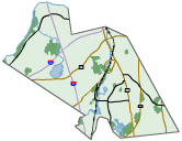
Interactive Map
Bay Circuit Trail
The Bay Circuit Trail is a trail from the north shore to the south shore of Massachusetts covering close to 200 miles. The Bay Circuit Trail route in North Andover and Andover covers 19.1 miles. Its sections are described in the Guidebook and include (from East to West):
The route of the Bay Circuit Trail is marked in Andover with two kinds of markings:
Shawsheen River Greenway
Since 1992, Andover volunteers have been working to improve public access to and appreciation of the Shawsheen River. The Shawsheen is the historic heart of our community, a recreational, conservation, and educational treasure. A multi-use path along the Shawsheen's banks could connect key features of the community. Between Ballardvale and Shawsheen Village, a river trail would link commuter bus parking, train station, high school and middle school, post office, shopping centers, Penguin Park, and existing conservation and AVIS lands.
In addition to protected land along the Shawsheen River included in the guidebook, several other town-owned or AVIS properties are along the river: conservation land at the corner of Central Street and Red Spring Road, undeveloped AVIS land between Essex and Stevens Streets, conservation land on the east side of Main Street, a new AVIS property also along Main Street, and a conservation easement opposite Brickstone Square. Efforts are underway to acquire conservation land in Andover adjacent to Den Rock Park. Lawrence and North Andover have also been improving citizens' access to their stretches of the river, including improvements to Den Rock Park and a walking path near North Andover Plaza.
The current focus of the Shawsheen Greenway is on preserving land and obtaining easements along the river. The public is encouraged to use the existing open space and to support future connections.
Interactive Map
Bay Circuit Trail
The Bay Circuit Trail is a trail from the north shore to the south shore of Massachusetts covering close to 200 miles. The Bay Circuit Trail route in North Andover and Andover covers 19.1 miles. Its sections are described in the Guidebook and include (from East to West):
- Harold Parker State Forest: Rte. 114 to Salem St. (2.5 miles); Salem St. to Jenkins Rd. (1 mile)
- Skug & Hammond Reservations: Jenkins Rd. to Salem St. (1 mile); Salem St. to Korinthian Way (0.5 mile); Korinthian Way & Gray Rd. (0.2 mile)
- Ward Reservation: Gray Rd. to Tucker Rd. (0.4 mile); Tucker Rd. to Prospect Rd. (1.6 miles); Prospect Rd. and Rte. 125 (0.3 mile)
- Phillips Academy & Purdon Reservation: Rte. 125 to Central St. (1.8 miles); Central St. to Lupine Rd. (0.2 mile); Lupine Rd., Central St., Reservation Rd.(0.4 mile)
- Indian Ridge & West Parish Meadow: Reservation Rd. to intersection of Cutler Rd. (1.3 miles)
- West Parish Cemetery & Doyle Link: Reservation & Cutler Rds. to Rte. 133 (Lowell St.) (0.5 mile); Rte. 133 (Lowell St.) to High Plain Rd. (1 mile); High Plain Rd. (1.4 miles)
- Rafton Reservation & Fish Brook: High Plain Rd. to jct. Chandler Rd. & River Rd. (2 miles); Launching Rd (0.3 mile)
- Deer Jump Reservation: Launching Rd. to Tewksbury town line (2.7 miles)
- Bay Circuit Trail Markings
The route of the Bay Circuit Trail is marked in Andover with two kinds of markings:
- 4" square plastic Bay Circuit logos at key trailheads
- Along the route, white dollar bill-sized blazes, oriented vertically and painted or nailed on trees or poles (in a few places, painted on curbs or sidewalks). One blaze means to continue straight along the trail. Two blazes on top of each other indicate a change ahead. If the upper blaze is offset to the left or right it indicates that the Trail will be turning in that direction.
Shawsheen River Greenway
Since 1992, Andover volunteers have been working to improve public access to and appreciation of the Shawsheen River. The Shawsheen is the historic heart of our community, a recreational, conservation, and educational treasure. A multi-use path along the Shawsheen's banks could connect key features of the community. Between Ballardvale and Shawsheen Village, a river trail would link commuter bus parking, train station, high school and middle school, post office, shopping centers, Penguin Park, and existing conservation and AVIS lands.
In addition to protected land along the Shawsheen River included in the guidebook, several other town-owned or AVIS properties are along the river: conservation land at the corner of Central Street and Red Spring Road, undeveloped AVIS land between Essex and Stevens Streets, conservation land on the east side of Main Street, a new AVIS property also along Main Street, and a conservation easement opposite Brickstone Square. Efforts are underway to acquire conservation land in Andover adjacent to Den Rock Park. Lawrence and North Andover have also been improving citizens' access to their stretches of the river, including improvements to Den Rock Park and a walking path near North Andover Plaza.
The current focus of the Shawsheen Greenway is on preserving land and obtaining easements along the river. The public is encouraged to use the existing open space and to support future connections.